
 Visit UKSC
Carla Anita Cecilia Braynen Turnquest (Respondent) v Water and Sewerage Corporation (Appellant) (Bahamas)
Case summary
Case ID
JCPC/2025/0050
Parties
Appellant(s)
Water and Sewerage Corporation
Respondent(s)
Carla Turnquest
Judgment details
Judgment date
21 September 2026
Neutral citation
[2026] UKPC 33
Hearing dates
Start date
30 June 2026
End date
30 June 2026
Justices


Judgment details
[2026] UKPC 33
LORD SNOWDEN:
1. This appeal arises from a dispute over the rights to a parcel of land of about a third of an acre at Mangrove Cay, Andros, The Bahamas (“the Land”). The respondent (“Mrs Turnquest”) claims to have inherited the Land from her father, Carl Braynen, who she contends acquired it as part of a conveyance of a larger piece of land from the estate of his grandfather, Albert Braynen, in 1963 (“the 1963 Conveyance”). The appellant (“WSC”) is the main water supplier in The Bahamas. It does not claim any documentary title, but asserts that it is entitled to the Land by adverse possession by reason of having erected and maintained two water storage tanks and associated apparatus on it to supply the Mangrove Cay community from about 1983.
2. Mrs Turnquest sued WSC for damages for trespass and delivery up of possession of the Land, but failed in her claim at trial before Madam Justice G Diane Stewart in December 2022. In essence, the judge found that the 1963 Conveyance was not a good root of title because it did not contain a proper description of the land which it conveyed, and there was no evidence showing how that land had come into the ownership of Albert Braynen so as to enable it to be conveyed by the 1963 Conveyance.
3. On 5 December 2023 the Court of Appeal (Sir Michael Barnett P, Madam Justice Charles and Mr Justice Turner JJA) reversed that decision. The Court of Appeal held that the judge had been wrong to require Mrs Turnquest to deduce title any earlier than the 1963 Conveyance; that Mrs Turnquest’s documentary title was superior to the possessory title claimed by WSC; and that WSC had not had the necessary intention to acquire title to the Land by adverse possession.
4. WSC appeals against that decision, both on the question of whether Mrs Turnquest had established documentary title to the Land and as to whether it had established a better title by adverse possession. For the reasons that follow the Board considers that the decision of the Court of Appeal should be upheld on both points, and WSC’s appeal should be dismissed.
5. Before dealing with those two points, it is necessary to describe the Land in issue.
The Land and the Survey Plan
6. The Land comprises a very short access road leading off Wellfield Road and terminating in a cleared area. The start of the access road is about 1,700 feet southwest along Wellfield Road from the junction with the main public highway in Mangrove Cay. The Land is surrounded by dense natural scrub vegetation. The cleared area at the end of the access road contains two water storage tanks and associated piping owned by WSC. The older tank, cubic in appearance and on a raised concrete pedestal to the north, now appears rusted, overgrown and disused. What appears to be a more modern tank to the south is a large vertical cylinder with its base on the ground: it is connected to some piping and surrounded by a chain link fence.
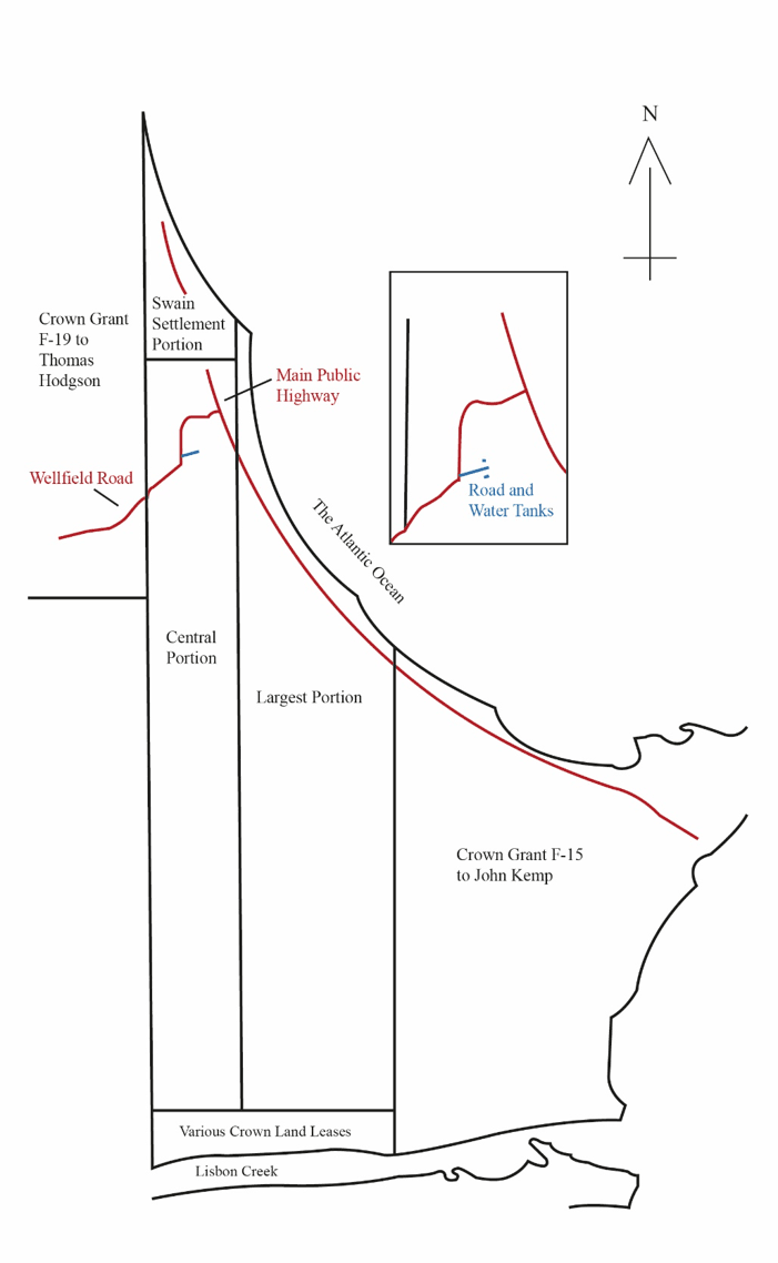
7. The Land is marked on a survey plan (numbered 600AN) (“the Survey Plan”) which was prepared in 2010 by a surveyor, Mr Emile Lédée. He had been instructed by Mrs Turnquest shortly after she had acquired the larger area of land left to her by her father, as she was considering developing it. It was Mr Lédée who discovered the presence of WSC’s apparatus on the Land and told Mrs Turnquest about it. The Survey Plan was registered with the Surveyor General on 24 May 2011. A highly simplified version is attached as an appendix to this judgment.
8. The Survey Plan plotted Mr Lédée’s assessment, based upon his physical surveys of the relevant land and review of a number of other registered plans, of the boundaries to three adjacent 18th century grants of Crown land. The three grants were roughly quadrilateral in shape, with boundaries running from the Atlantic coastline in the north down towards Lisbon Creek to the south. From west to east, they were (i) Crown Grant F-19 to Thomas Hodgson, (ii) Crown Grant F-28 to Joseph Evans, and (iii) Crown Grant F-15 to John Kemp.
9. Mr Lédée also marked on the Survey Plan his assessment of how Crown Grant F-28 to Joseph Evans had been divided up according to the bequests of one William Henry Sweeting in his will executed in 1875 (Register Book: R-8 Pages 418-420) (“the Sweeting Will”). The Survey Plan showed Crown Grant F-28 divided up into three portions:
(i) The most northerly portion fronted onto the Atlantic coastline and had a westerly boundary with Crown Grant F-19 to Thomas Hodgson. As measured, it comprised 130.68 acres. This is referred to below as “the Swain Settlement Portion”.
(ii) Immediately to the south of the Swain Settlement Portion was a rectangular portion of 862.51 acres. This is referred to below as “the Central Portion”. The western boundary of the Central Portion was a continuation of the western boundary of the Swain Settlement Portion.
(iii) The third and largest portion was immediately to the east of the Central Portion. It measured 1,123.88 acres. This is referred to below as “the Largest Portion”. The Largest Portion was bounded to the east by Crown Grant F-15 to John Kemp.
10. Mr Lédée’s evidence was that the Central Portion shown on his Survey Plan was the land that had been bequeathed in the Sweeting Will to a Phoebe Ann Braynen, and that it included the Land. Mrs Turnquest’s case is that the Central Portion was the land conveyed to her father, Carl, by the 1963 Conveyance.
Documentary title to the Land
11. The first group of questions on this appeal relate to the question of whether Mrs Turnquest can rely upon the 1963 Conveyance as a root of title; and if she can rely upon the 1963 Conveyance, whether it sufficiently identifies the Land.
The documents
12. The documentary history starts with Crown Grant F-28 to Joseph Evans in 1787. That Grant stated that it comprised 1,500 acres. It included a rough handwritten sketch that approximately corresponded with the shape of the Grant plotted by Mr Lédée on the Survey Plan. Mr Lédée’s evidence was that Crown Grant F-28 in fact measured 2,117.07 acres in total. It was common ground between the parties that the acreages shown in older documents were inaccurate when compared with the precise acreages shown in plans measured using modern equipment.
13. The next relevant document was the Sweeting Will of 1875. By that will, William Henry Sweeting made the following bequests:
“… I give, devise, and bequeath to my Son Arthur Thomas for his natural life, at his death to be equally divided among his lawful children eight hundred and sixty acres of my tract of land on Andros Island situate between Southern and Middle Bights opposite Mangrove Cay, part of a tract originally granted to a certain Joseph Evans, the said eight hundred and sixty acres to adjoin the Eastern line of said original tract and land granted John Kemp. To Phoebe Ann Braynen I give devise and bequeath, for her life time, and at her death to be equally divided among her lawful children, six hundred and sixty acres of the aforesaid tract on Andros Island, the said six hundred and sixty acres to adjoin a portion of that Western line of said original tract. To my sister Seva Butler, widow, I give, devise and bequeath one hundred acres of the aforesaid original tract on said Island which is to adjoin, on the West, land formerly granted to Thomas Hodgson and fronting on the sea.”
14. Mr Lédée’s evidence, reflected in his Survey Plan, was that the parcel bequeathed to Arthur Thomas Sweeting was the Largest Portion; the parcel bequeathed to Phoebe Ann Braynen was the Central Portion; and the parcel bequeathed to Seva Butler was the Swain Settlement Portion. As indicated, he attributed the disparity between the stated acreages and the measured acreages of the Portions to modern measuring techniques.
15. There was, however, no document to show how any of the land comprised in Crown Grant F-28 to Joseph Evans had come into the ownership of William Sweeting. To that extent there was a gap in the chain of title from Crown Grant F-28 to the Sweeting Will.
16. The next relevant document was the 1963 Conveyance. That document was prepared by Carl Braynen. It provided for a sale of a piece of land to him from his mother (Lauretta Braynen), acting as executor of the estate of her father (Albert Braynen). The operative part of the 1963 Conveyance provided that in consideration of a payment of £1,000:
“… [Lauretta Braynen] as Administrator of the Estate of Albert Braynen Deceased … hereby grants and conveys to [Carl Braynen] all that piece parcel or lot of land containing Six hundred and Sixty (660) acres more or less being a portion of a 860 acres out of tract of land granted to Joseph Evans and situated at the Settlement of Mangrove Cay Andros one of the Bahama Islands between Middle and Southern Bight more particularly described in the Will of William Henry Sweeting late of Mangrove Cay Andros which Will is recorded in Book R.8 at pages 418 to 424. To hold the same and to the use of [Carl Braynen] his heirs and assigns in Fee Simple.”
17. There was no dispute that the reference in the 1963 Conveyance to the “Will of William Henry Sweeting” was to the Sweeting Will. However, there was no document to show how Albert Braynen had come to own any of the land mentioned in the Sweeting Will, and no reference to such land had been made in any of the probate documents filed in connection with the administration of his estate. To that extent there was a further gap in the chain of title from the bequests in the Sweeting Will to the 1963 Conveyance. Moreover, the 1963 Conveyance had no plan attached to it that might have clearly identified the land conveyed.
18. The next relevant document was Carl Braynen’s last will and testament dated 13 September 2007. By his will, Carl Braynen appointed Mrs Turnquest as sole executrix and devised and bequeathed all his real and personal property to her in fee simple absolutely. Carl Braynen died on 8 October 2007. A grant of probate was issued to Mrs Turnquest on 19 August 2009, and on 14 October 2009 she executed a deed of assent in her own favour in respect of all the property included in her late father’s bequest. Although the validity of the chain of title leading up to the 1963 Conveyance was disputed by WSC, it was not disputed that if the 1963 Conveyance was a good root of title to the Land, these later documents formed a valid chain of title to Mrs Turnquest.
The decisions of the courts below
19. At first instance, the trial judge referred to the common law definitions of a good root of title adopted by Charles J in Re Eleuthera Land Company Limited [2019] 1 BHS J No 36, a case under the Quieting Titles Act 1959. These included the definition in what is now Megarry and Wade: The Law of Real Property (“Megarry and Wade”), 10th ed (2024), para 14-077:
“A good root of title is a document which describes the land sufficiently to identify it, which shows a disposition of the whole legal and equitable interest contracted to be sold, and which contains nothing to throw any doubt on the title.”
20. The judge also referred to section 3(4) of the Conveyancing and Law of Property Act 1909 (“the CLPA”), which provides, under the heading “Contracts for Sale”,
“(4) A purchaser of land shall not be entitled to require a title to be deduced for a period of more than thirty years, or for a period extending further back than a grant or lease by the Crown or a certificate of title granted by the court in accordance with the provisions of the Quieting Titles Act, whichever period shall be the shorter.”
21. On the evidence, the judge referred to the gaps in the chain of title between Crown Grant F-28 and the 1963 Conveyance referred to above, together with the absence of any mention of any relevant land in Albert Braynen’s probate documents. The judge also commented that reliance on the 1963 Conveyance was “questionable as there is no plan attached to describe the property referred to nor is there a proper description of the [p]roperty”. The judge concluded, at para 143 of her judgment, that these matters meant that she was not satisfied that Mrs Turnquest could prove “a good and marketable documentary title to [the Land] as is required to be shown by section 3(4) of the CLPA”. She also held, at para 148, that there was no document which met the common law definition of a good root of title; that the fact that the 1963 Conveyance was over thirty years old was “not dispositive of the issue”; and that “When the title is being disputed, more is required to establish a good root of title”.
22. Having determined that the 1963 Conveyance was not a good root of title, the trial judge also made some brief findings based upon the evidence she had heard concerning the accuracy of the Survey Plan. Those findings are considered in greater detail below.
23. In its judgment on the issue of documentary title, the Court of Appeal held (at para 50) that in an action for trespass, all that a claimant is required to do is to show that their title is superior to that of the person who they claim is trespassing on the land. It therefore held (at para 53) that the trial judge had erred in requiring Mrs Turnquest to show “good and marketable documentary title” to the Land by reference to section 3(4) of the CLPA; and (at para 58) that cases under the Quieting Titles Act 1959 were distinguishable. Later in its judgment the Court of Appeal also held, at paras 77–81, that “Applying section 3(4) of the CLPA” the judge was not entitled to require Mrs Turnquest to deduce title prior to the 1963 Conveyance.
24. Having held that all Mrs Turnquest had to do was to show a superior title to that of WSC, the Court of Appeal also stated that because WSC did not assert anything other than a possessory title:
“any documentary title put forth by [Mrs Turnquest] (even with defects) was a better title than [WSC’s] title.”
It reiterated this point by stating, at para 59, that it did not matter that Mrs Turnquest’s documentary title “may not have been perfect as there is no such thing as a perfect title”. At paras 71–72 the Court of Appeal also placed reliance on the fact that the evidence at trial was that a Computitle search had not revealed any other documentary root of title to the Land.
25. The Court of Appeal then held, at paras 73–76 that the trial judge had erred in finding that the 1963 Conveyance did not properly identify the property conveyed. The Court of Appeal’s reasoning was expressed very briefly. It simply stated, at para 75:
“It is clear that the description includes, among other things, the size and location of the land conveyed and the description of the land by reference to the original Crown Grant to Joseph Evans and the subsequent 1875 Will of William Henry Sweeting along with its recording reference.”
26. Finally, at para 82, the Court of Appeal concluded that the judge had erred in stating that the Survey Plan did not prove that Mrs Turnquest owned the Land because “the property surveyed by [the Survey Plan] was the property described in the 1963 Conveyance”.
27. In consequence, at para 83, the Court of Appeal concluded that the judge had wrongly rejected Mrs Turnquest’s documentary title to the Land.
This appeal
28. WSC appeals on a number of grounds. In summary, the main grounds of appeal are (i) that the Court of Appeal erred in holding that the documentary title claimed by Mrs Turnquest (even with defects) was superior to the possessory title claimed by WSC; (ii) that the Court of Appeal erred in holding that the trial judge was not entitled to require Mrs Turnquest to deduce title prior to the 1963 Conveyance; (iii) that the Court of Appeal should have held that the absence of any earlier document showing how Albert Braynen came to own the property conveyed in the 1963 Conveyance meant that it was not a good documentary root of title to the Land; and (iv) that the Court of Appeal erred in holding that the 1963 Conveyance properly identified the Land.
The root of title requirement as against a trespasser
29. There was no dispute that WSC had constructed the access road and had installed the water storage tanks and fence on the Land. That being so, the basic legal position was as explained by Lord Macnaghten in Perry v Clissold [1907] AC 73, 79:
“It cannot be disputed that a person in possession of land in the assumed character of owner and exercising peaceably the ordinary rights of ownership has a perfectly good title against all the world but the rightful owner. And if the rightful owner does not come forward and assert his title by process of law within the period prescribed by the provisions of the Statute of Limitations applicable to the case, his right is for ever extinguished, and the possessory owner acquires an absolute title.”
30. Although Mrs Turnquest was therefore required to assert her title to the Land to support her claim for trespass against WSC, it did not mean that she had to prove the same quality of title that would have been required if she were a vendor seeking to enforce a contract for sale. That was the point made by Lord Diplock in Ocean Estates Ltd v Pinder [1969] 2 AC 19. In that case, the Court of Appeal had rejected the appellant’s claim in trespass because it was based upon a conveyance of the relevant land that was less than 30 years old and hence could not have been relied upon by a vendor under section 3(4) of the CLPA. The appeal was allowed by the Privy Council. At pages 24H–25B, Lord Diplock stated:
“In their Lordships’ view the question of what documentary title a vendor is entitled to insist on forcing upon a purchaser has no relevance to the present action. At common law as applied in the Bahamas, which have not adopted the English Land Registration Act, 1925, there is no such concept as an ‘absolute’ title. Where questions of title to land arise in litigation the court is concerned only with the relative strengths of the titles proved by the rival claimants. If party A can prove a better title than party B he is entitled to succeed notwithstanding that C may have a better title than A, if C is neither a party to the action nor a person by whose authority B is in possession or occupation of the land. It follows that as against a defendant whose entry upon the land was made as a trespasser a plaintiff who can prove any documentary title to the land is entitled to recover possession of the land unless debarred under the Real Property Limitation Act by effluxion of the 20-year period of continuous and exclusive possession by the trespasser.”
31. It follows that section 3(4) of the CLPA—which by its terms applies to a contract between vendor and purchaser—was inapplicable in this case. It also follows that there was no basis upon which Mrs Turnquest could be required to satisfy the strict requirements of deducing either “good title” or a “good marketable title”. Those are concepts used in conveyancing cases between vendor and purchaser: see the explanation of Millett LJ in Barclays Bank plc v Weeks Legg & Dean [1999] QB 309 at 324B–325G.
32. Nor was Mrs Turnquest required to deduce title to the Land in the same manner as if she had been seeking a certificate of title from the court under the Quieting Titles Act 1959. As explained in Bannerman Town, Millars and John Millars Eleuthera Association v Eleuthera Properties Ltd [2018] UKPC 27 (“Bannerman Town”) at paras 35–38, that Act gives the court a general power to investigate and grant a certificate of title to any person who claims to have an estate or interest in land. The process used under the Act is one that implicitly adopts and builds on the common law and statutory provisions governing the practice of deducing title as between vendors and purchasers of land. In contradistinction to a claim in trespass, it results in the grant of a certificate of title that is, absent fraud, good against the world.
33. The Board therefore accepts that documents suffering from defects which might prevent them from qualifying as a “good title” or even as a “good marketable title” for the purposes of a dispute between vendor and purchaser, might nevertheless be sufficient to found a valid case against a trespasser with no documentary title. Further, the Board considers that a court hearing a claim for damages for trespass and recovery of possession is entitled to have regard to a broader range of extrinsic evidence that might not be admissible if the question was whether a particular document was a good root of title for the purposes of a dispute between vendor and purchaser. So in the instant case, for example, the Court of Appeal was entitled to have regard to the evidence that a Computitle search had not revealed that there were any other documents relating to the Land apart from the 1963 Conveyance.
34. But there must be some limits. It cannot be the case that literally “any” documentary title, no matter how great its defects, is necessarily better than a possessory title, as the Court of Appeal appeared to suggest in paras 51 and 59 of its judgment (see above). The documentary title relied upon by the plaintiff must, for example, be of an estate or interest that gives a right to possession, and the right must exist over the specific land in question. Those requirements are implicit in the decisions in Perry v Clissold and Ocean Estates Ltd v Pinder.
35. Although the plaintiff in an action for trespass can rely upon a wider range of evidence to establish their title than would be the case in a dispute between vendor and purchaser, the Court of Appeal was right to hold that the plaintiff cannot be required to prove a good root of title going back further than the relevant period specified in section 3(4) of the CLPA. That is not because section 3(4) is directly applicable to such cases. It is not, and the suggestion to that effect by the Court of Appeal in para 81 of its judgment was wrong. Rather, it is because to require a plaintiff to prove a root of title of greater age than the relevant period in section 3(4) would be contrary to the framework of the CLPA and the Quieting Titles Act.
36. The rationale and connection between the title, adverse possession and limitation is explained in Megarry and Wade at para 7-014 (citations omitted):
“Limitation also fulfils another important function. It facilitates the investigation of title to unregistered land. Possession is the root of unregistered title, such title is relative, and the owner is the person who has the best right to possess the land. Adverse possession extinguishes earlier rights to possess and thereby reduces the period of title which an intending purchaser must investigate. That period of title … is directly related to the limitation period and this has long been the case. The statutes of limitation have therefore provided ‘a kind of qualified guarantee that any possible outstanding claims to ownership by third parties are time-barred’.”
37. In Bannerman Town at para 37, Lord Briggs explained that:
“Section 3(4) of the [CLPA] recognises and implements the common law principle and practice that a vendor may deduce and prove documentary title by reference to a good root of title of sufficient antiquity, prescribing 30 years as the generally applicable period for that purpose.”
38. Given these connections, it would be irrational for the law to require a claimant in an action for trespass to deduce a root of title older than the appropriate period prescribed in section 3(4) of the CLPA. Put another way, if as a matter of conveyancing law, a purchaser cannot insist on the vendor deducing title for more than the prescribed period under section 3(4), it would be irrational if the purchaser was subsequently required to deduce title for a longer period in order to be able to claim possession of the land from a trespasser. The risk of a purchaser being exposed in this way would be a manifest defect in the conveyancing system.
39. That conclusion is also supported by the terms of section 8(2) of the Quieting Titles Act 1959. That section provides that in an action under the Act:
“It shall not be necessary to require a title to be deduced for a longer period than is mentioned in subsection (4) of section 3 of the Conveyancing and Law of Property Act or to produce any evidence which by the Conveyancing and Law of Property Act is dispensed with as between vendor and purchaser, or to produce or account for the originals of any recorded deeds, documents or instruments, unless the court otherwise directs.”
40. Accordingly, a party to a quieting action cannot be required (unless the court otherwise directs) to deduce title for a longer period than that referred to in section 3(4) of the CLPA. As indicated above, the successful party in such an action will obtain a certificate of title from the court which (absent fraud) is intended to be conclusive as to its contents against the world: see section 19 of the Quieting Titles Act 1959. For similar reasons to those explained above in relation to an ordinary purchaser, it would be contrary to the purposes and scheme of the 1959 Act if a person holding such a certificate of title from the court was required to deduce title for a longer period in order to be able to claim possession of land from a trespasser. This would undermine the effect of the certificate of title and leave the holder exposed to the risk of being unable to assert their title to the land.
41. The Board therefore considers, albeit not for entirely the same reasons, that the Court of Appeal was right to hold in para 81 that the trial judge should not have required Mrs Turnquest to prove her title to the Land by reference to a document older than the 1963 Conveyance.
Whether Mrs Turnquest’s root of title was sufficient in this case
42. The next issue on the appeal is whether the 1963 Conveyance was a sufficient root of title giving Mrs Turnquest a right to possession of the Land. It will be recalled that the operative provisions of the 1963 Conveyance were:
“… [Lauretta Braynen] as Administrator of the Estate of Albert Braynen Deceased … hereby grants and conveys to [Carl Braynen] all that piece parcel or lot of land containing Six hundred and Sixty (660) acres more or less being a portion of a 860 acres out of tract of land granted to Joseph Evans and situated at the Settlement of Mangrove Cay Andros one of the Bahama Islands between Middle and Southern Bight more particularly described in the Will of William Henry Sweeting late of Mangrove Cay Andros … To hold the same and to the use of [Carl Braynen] his heirs and assigns in Fee Simple.”
43. It was not suggested that the 1963 Conveyance did not purport to convey an estate in land giving a right to possession. The focus of the attack by WSC was that the 1963 Conveyance did not sufficiently identify the land conveyed in it. There were two aspects to this attack: the first was that the description of the property conveyed in the document was ambiguous and imprecise, and the second was that it did not enable precise identification of the location of the relevant land on the ground.
44. On the first point, a straightforward reading of the 1963 Conveyance is that it intended to convey a piece of land containing “660 acres more or less” out of the Crown Grant to Joseph Evans as “more particularly described” in the Sweeting Will. That would be an obvious cross-reference to the parcel of land said to contain about 660 acres which William Henry Sweeting bequeathed to Phoebe Ann Braynen. That would also make sense having regard to the context of the 1963 Conveyance. The 1963 Conveyance was executed by Lauretta Braynen as administrator of the estate of her late father, Albert Braynen, and in favour of her son, Carl Braynen. Whatever the motive behind the 1963 Conveyance, there was no obvious reason for either Lauretta or Carl to have been intending to deal with anything other than the land that had previously been bequeathed to their ancestor, Phoebe Ann Braynen.
45. This interpretation does leave unexplained the reference to “860 acres” in the 1963 Conveyance. As indicated above, the Sweeting Will made three bequests: together these comprised about 1,620 acres, not 860 acres. If the intention was to convey a parcel of about 660 acres out of that total acreage, the reference to 860 acres was an obvious error.
46. Alternatively, the Sweeting Will did contain a specific bequest of 860 acres to William Sweeting’s son, Arthur Thomas Sweeting. But given the context, it would make no sense for the parties to the 1963 Conveyance to have been intending to convey about 660 acres out of the 860 acres originally left to Arthur Thomas Sweeting: he had no connection with the Braynen family. The Board also notes, in passing, that this second potential interpretation of the clause does not appear to have been advanced by WSC at trial.
47. The correct conclusion must be, therefore, that the reference to 860 acres in the 1963 Conveyance was a mistake in drafting. That error is more easily understood when it is appreciated that the 1963 Conveyance was not a professionally drafted document, but was drawn up by Carl Braynen, who was described as a “Realtor” in the document, and had no formal legal training. Properly interpreted, the 1963 Conveyance identified and was intended to convey the same piece of land that had been bequeathed to Phoebe Ann Braynen in the Sweeting Will.
48. That conclusion does not, however, resolve the second issue of whether the location of the land bequeathed to Phoebe Ann Braynen can now be identified on the ground on Andros. More particularly, since the instant case is about whether WSC is liable for trespass on the Land, the question is whether the bequest to Phoebe Ann Braynen included the Land.
49. In that respect, it is unfortunate that the trial judge, who heard cross-examination of Mr Lédée, did not make her findings entirely clear as regards the Survey Plan. The judge first defined the “Property” in para 1 of her judgment in terms that correspond to “the Land” as defined earlier. The judge then stated, at paras 151–153,
“151. The parties dispute whether [the Survey Plan] is accurate. [Mrs Turnquest] who relies on it to show the boundaries of the Property of course submits that it is. However, [WSC] submits that it is not and questions the conduct of Mr Lédée in the survey and work done in order to prepare [the Survey Plan]. In addition to [the Survey Plan], there is evidence agreed to by both parties which shows that both parties accepted that [WSC’s] water holding tanks and storage were situate on the Property.
152. Both parties have, as they should, vigorously fought to highlight the discrepancies and consistencies in each other’s case. Ultimately, the Court, in following set guidelines and principles of evidence and procedural rules must make a determination of which evidence to consider and the veracity of the same. In considering the evidence before me, I find that the property claimed by [Mrs Turnquest] is that on which the water holding tanks and storage are situate.
153. The issue of whether the [Survey Plan] is correct or valid does not in my view dispose of the issue. I accept, however, that the survey was properly registered with the Department of Lands [and] Surveys and is proof of property surveyed therein, however it does not prove that [Mrs Turnquest] owned the Property.”
The judge returned to this topic when summarising her decision in para 166 of her judgment:
“166. … I am satisfied that the survey which was duly registered with the Department of Lands and Survey[s] only set out the boundaries to the Property in question but did not determine who owned it.”
50. Read literally, these findings might suggest that all that the judge determined was that WSC’s water tanks were on the Land and the Survey Plan “only set out the boundaries to the Property in question”. That would have been a very limited finding relating only to the boundaries to the very small piece of land which has been defined as “the Land”. However, this would be to read the judgment too literally and cannot be what the judge meant.
51. The first point to note in that regard is that the exact boundaries to the Land were not actually in dispute, and, as recorded in para 151, the parties were agreed that WSC’s water tanks are situated on it. In para 151, the judge correctly identified that the real dispute between the parties was whether the Survey Plan was accurate, and in paras 151 and 152 she described the substantial argument that had taken place on the evidence at trial. The transcript of the cross-examination of Mr Lédée shows that WSC mounted a broad challenge to Mr Lédée’s work and to his opinion of where the boundaries of the Crown Grants and the three portions of land bequeathed in the Sweeting Will were located.
52. Given the nature of the dispute, the Board considers that the judge’s finding in the last sentence of para 152 and her acceptance in para 153 that the Survey Plan was “proof of [the] property surveyed therein” were intended to be a broader finding that the Survey Plan accurately showed the boundaries to the Crown Grants and to the three portions of land bequeathed in the Sweeting Will; and more particularly that the judge took the view that the Survey Plan accurately placed the Land within the Central Portion. That is also supported by the fact that the judge did not indicate any material respect in which she found that the Survey Plan was inaccurate or give any explanation for such a finding. It is also consistent with the start of para 153, which implies that the judge had decided that the Survey Plan was “correct or valid”.
53. Further, to the extent that it is relevant to the issues in this case, that was a conclusion that the judge was entitled to reach on the evidence for the following reasons.
54. First, it is clear from the description given in the Sweeting Will that the “one hundred acres” bequeathed to Seva Butler was a reference to the Swain Settlement Portion as shown on the Survey Plan. That is because the land bequeathed to Seva Butler must be located within the original Crown Grant F-28 to Joseph Evans and lie between the Atlantic Ocean to the north and the land granted to Thomas Hodgson to the west. Likewise, it is clear from the description in the Sweeting Will that the “eight hundred and sixty acres” bequeathed to Arthur Thomas Sweeting must be a reference to the Largest Portion shown on the Survey Plan. That is because it must be within the original grant to Joseph Evans and be adjoining the land originally granted to John Kemp to the east. By a process of elimination, the remaining land is the Central Portion bequeathed to Phoebe Ann Braynen, which must include the Land.
55. As explained earlier, the disparity between the references in the Sweeting Will to 100 acres and 860 acres for the Swain Settlement Portion and the Largest Portion respectively, and the modern measurements of those areas as 130.68 acres and 1,123.88 acres, is not significant given the strong contrary indicators in this case as to which land is being referred to in the documents. Indeed, if the Swain Settlement Portion was only 100 acres in size and the Largest Portion was only 860 acres in size, since those areas would be measured from the boundaries with the other two original Crown Grants referred to above, it would be even more obvious that the Land would be located within the remaining Central Portion.
56. For these reasons the Board concludes that the result reached by the Court of Appeal was correct, namely that Mrs Turnquest had established documentary title to the Land that enabled her to found a claim in trespass and for delivery up of possession against WSC.
WSC’s claim to title by adverse possession
57. The Board therefore turns to the second question, namely whether WSC had established title to the Land by adverse possession.
The law
58. The essential requirements for a successful claim in adverse possession were not materially in issue between the parties in the courts below or before the Board. They were succinctly summarised by Lord Browne-Wilkinson in J A Pye (Oxford) Ltd v Graham [2003] 1 AC 419 at para 36:
“The question is simply whether the defendant squatter has dispossessed the paper owner by going into ordinary possession of the land for the requisite period without the consent of the owner.”
59. In J A Pye, Lord Browne-Wilkinson then considered what might constitute “possession”. He referred, with approval, to the decision of Slade J in Powell v McFarlane (1977) 38 P & CR 452 and concluded, at para 40, that:
“there are two elements necessary for legal possession: (1) a sufficient degree of physical custody and control (‘factual possession’); and (2) an intention to exercise such custody and control on one’s own behalf and for one’s own benefit (‘intention to possess’).”
60. At para 41, Lord Browne-Wilkinson then expressly agreed with the following statement of principle by Slade J in Powell at pages 470–471:
“Factual possession signifies an appropriate degree of physical control. It must be a single and conclusive possession, though there can be a single possession exercised by or on behalf of several persons jointly. Thus an owner of land and a person intruding on that land without his consent cannot both be in possession of the land at the same time. The question what acts constitute a sufficient degree of exclusive physical control must depend on the circumstances, in particular the nature of the land and the manner in which land of that nature is commonly used or enjoyed … Everything must depend on the particular circumstances, but broadly, I think what must be shown as constituting factual possession is that the alleged possessor has been dealing with the land in question as an occupying owner might have been expected to deal with it and that no-one else has done so.”
61. Reference should also be made to the statement of Robert Walker LJ in Simpson v Fergus (1999) 79 P & CR 398, 402:
“Possession is a legal concept which depends on the performance of overt acts, and not on intention (although intention is no doubt a necessary ingredient in the concept of adverse possession). It may or may not be sufficient in international law to annex an uninhabited and uninhabitable rock by planting a flag on it … But to establish exclusive possession under English law [requires] much more than a declaration of intention, however plain that declaration is[.] Actual occupation and enclosure by fencing is the clearest, and perhaps the most classic, way of establishing exclusive possession (though even enclosure is not invariably enough …).”
In Bannerman Town at paras 73–74, Lord Briggs indicated that there was no reason why these principles should not be applicable in The Bahamas, or why they should not apply to land which, like the Land in this case, was largely wild scrubland.
62. Finally, and importantly, in the extract from Perry v Clissold [1907] AC 73 at page 79 cited above, Lord Macnaghten held that possession sufficient to bar a prior title must be proved for the whole of the time prescribed by the relevant Limitation Act. This statement of principle was also endorsed by Lord Briggs in Bannerman Town at para 50.
The evidence and decisions below
63. The evidence of WSC’s occupation of the Land at trial was sparse. It consisted entirely of a very short witness statement from Mr Gibson, its local assistant general manager. He stated that he had been told by his general manager, who had investigated the matter, that WSC had gone into possession of the Land “sometime in 1978 and constructed the well field and water distribution system on this property at that time”.
64. Mr Gibson also exhibited a document dated 14 April 1983 which was a memorandum from a Mr Hewitt who was a junior employee of the Ministry of Works & Utilities to its Permanent Secretary (“the 1983 Memorandum”). That 1983 Memorandum explained that difficulties were “being experienced in maintaining efficiently the wellfield and water distribution system in Mangrove Cay”. It mentioned pumps located three miles west of the main road and seven miles of distribution system, but made no specific mention of any access road or water storage tanks located on the Land or anywhere else.
65. At para 155 of her judgment, the trial judge held that the 1983 Memorandum “reflects the presence of a wellfield and water distribution system owned by [WSC] in Mangrove Cay”, that “it is evidence of possession of the [Land] by [WSC]”, and that “considerable weight should be given to this document”. At para 165, the judge concluded that:
“even if I am mistaken in finding with respect to [Mrs Turnquest’s] title, [WSC] occupied the [Land] undisturbed and was utilizing the water tanks and water storage facility units from at least 1983 when the 1983 [Memorandum] was issued confirming their presence thereon.”
66. At para 95 of its judgment, the Court of Appeal rejected this conclusion, saying:
“It seems to us that the learned judge erred in law when she placed reliance upon [the 1983 Memorandum] as the basis for its possessory title where, as [Mrs Turnquest] alleges, assuming that the 1983 Memorandum related to the [Land], taken at its highest, it would only demonstrate factual possession but not the requisite intention to possess the [Land] to the exclusion of all others.”
67. At paras 97 and 98, the Court of Appeal also held that the trial judge had failed to have proper regard to the response of WSC when Mrs Turnquest’s lawyer wrote to it in November 2012 alleging trespass. Initially WSC asked for time to investigate title to the Land, following which there was a long delay before WSC responded in April 2016, asking Mrs Turnquest to provide proof of her ownership and making a proposal for WSC’s “outright purchase, or extended lease” of the Land. That led to Mrs Turnquest asking in 2018 for a payment of $20,000 in partial settlement of her claim, to which WSC responded by issuing a cheque for that amount which was expressed to be “the initial payment for use of private land by the Corporation in Mangrove Cay[,] Andros”. The Court of Appeal held that these responses and offers “could never be indicative of an intention by [WSC] to exclude the true owner and the world from the [Land]” and that they were in fact an acknowledgement that WSC was not the owner and had no interest in the Land.
Conclusions as to adverse possession
68. The Board entirely agrees with the Court of Appeal on the question of adverse possession.
69. Except for the vague, unsubstantiated and second-hand evidence of Mr Gibson, there was simply no evidence as to when WSC had made the access road or installed either of the storage tanks or other apparatus on the Land. The judge’s reliance on the 1983 Memorandum was also entirely misplaced, because it does not refer to the Land or the presence of water tanks or any other facilities on it at all.
70. Still less was there any evidence as to when WSC had done any objective act that could conceivably have indicated an intention to exclude other people from any part of the Land. There was no evidence of any signage indicating WSC’s occupation of the Land or seeking to exclude others from it. The only potential evidence of such intention was the wire fence around the cylindrical tank. But there was no evidence as to when that tank or the fence was installed, and from the photographs adduced by Mrs Turnquest they are obviously a more recent installation than the older cubic tank that is unfenced.
71. As the Court of Appeal rightly held, the complete lack of any evidence of objective acts by WSC that might indicate an intention to occupy the Land to the exclusion of others throughout the relevant limitation period is also consistent with WSC’s response to Mrs Turnquest’s correspondence raising a claim for trespass. In particular, it is notable that WSC did not assert that it had title to the Land for a considerable period of time. Nor did it contend that it had sought and obtained permission from anyone else to occupy the Land. Instead, it first offered to buy or lease it and then paid $20,000 “for use of private land”.
72. In light of the Board’s decision on that issue, it is not necessary to express any view on an alternative argument advanced by Mrs Turnquest under section 38 of the Limitation Act 1995 that WSC’s offer to purchase the Land and payment of $20,000 for use of it amounted to an acknowledgment of her title which reset the clock for the purposes of its claim to the Land by adverse possession.
Conclusion
73. The Board will therefore humbly advise His Majesty that WSC’s appeal should be dismissed.
Annex - Simplified Survey Plan